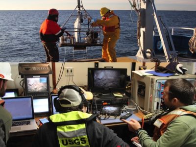
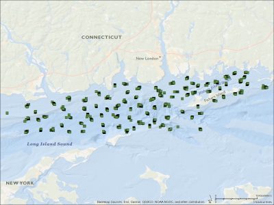
The LISMaRC partner, the US Geological Survey (USGS), has recently published the data collected during two marine geological surveys conducted in Long Island Sound, Connecticut and New York, in fall 2017 and spring 2018. The surveys were conducted using the SEABed Observation and Sampling System (SEABOSS) operated from the Research Vessel (RV) Connecticut. The SEABOSS collected sea-floor images and videos at 210 sampling sites within the Phase II area, and surficial sediment samples at 179 of the sites. The sediment data and the observations from the images and videos are used to identify sediment texture and are core components used to identify sea-floor habitats.
The data release provides access to the locations and grain-size analysis results of surficial sediments collected with a modified Van Veen grab sampler on the SEABOSS during USGS field activities 2017-056-FA (November 28 to December 3, 2017) and 2018-018-FA (May 8 to 15, 2018). These data were collected to explore the nature of the sea floor and to characterize the seabed by identifying sediment texture. The sediments were analyzed using two different methods: the Beckman Coulter Multisizer 3 and sieving of the >= 4-phi fraction, and the HORIBA LA-960 laser diffraction analyzer and sieving of the >= -2-phi fraction. The HORIBA LA-960 laser diffraction analyzer is a new method for analyzing grain-size distribution at the sediment laboratory at the USGS Woods Hole Coastal and Marine Science Center. This dataset was analyzed using both methods so that the results could be compared. Results of the comparison are not included in this data release.
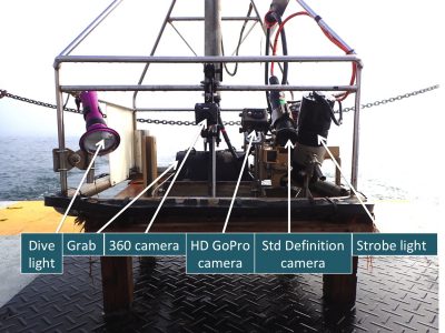
The dataset also provides access to the sea-floor images (.jpg format) and video clips (.mp4 format) and their locations acquired with a Nikon D300 digital still camera, a GoPro HERO4 Black camera, and a Kongsberg Simrad OE1365 video camera mounted on the SEABOSS. These data were collected to explore the nature of the sea floor and to characterize the seabed by identifying sediment texture. Bottom images and videos serve as a means to visually classify grain size and identify sea-floor habitats, and they are especially important for sample sites where no physical sediment sample was collected.
The entire data release provides complete metadata and the geotagged sea-floor images, location of bottom images, sea-floor videos, and location of bottom video tracklines collected during the surveys. The data citation and doi access is:
Ackerman, S.D., Huntley, E.C., Blackwood, D.S., Babb, I.G., Zajac, R.N., Conroy, C.W., Auster, P.J., Schneeberger, C.L., and Walton, O.L., 2020, Sea-floor sediment and imagery data collected in Long Island Sound, Connecticut and New York, 2017 and 2018: U.S. Geological Survey data release, https://doi.org/10.5066/P9GK29NM