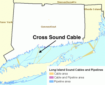
In June 2004, a court settlement brought by the states of Connecticut and New York against the Cross Sound Cable Company resulted in a fund that was to support projects to enhance Long Island Sound (LIS) and to improve understanding of the biological, chemical and physical effects of existing or potential cables and pipelines crossing the Sound. The Long Island Sound Study Policy Committee signed a Memorandum of Understanding on administering the fund for research and restoration projects to enhance the waters and related natural resources of Long Island Sound. In 2006, the Long Island Sound Study Policy Committee signed a second Memorandum of Understanding formally establishing a framework for the fund’s use. The Policy Committee agreed that the Fund be used to: “Emphasize benthic mapping as a priority need, essential to an improved scientific basis for management and mitigation decisions.” Therefore, the settlement fund valued at more than $7 million, is being directed toward seafloor mapping activities over the next several years.
This improved spatial information of the benthic environment of LIS will both identify areas of special resource concern, as well as identify areas that may be more suitable for the placement of energy and other infrastructure. The comprehensive mapping activities will assist managers in the States of Connecticut and New York, Connecticut and New York Sea Grant programs, and the U.S. Environmental Protection Agency (USEPA) with their mandates to preserve and protect coastal and estuarine environments and water quality of Long Island Sound. The ultimate goal is to balance competing human uses and energy needs with protection and restoration of essential ecological function and habitats.
The Long Island Sound Seafloor Mapping Workshop
The Connecticut Department of Energy and Environmental Protection (DEEP) Office of Long Island Sound Programs (OLISP), the University of Connecticut Marine Sciences Department, and the EPA Long Island Sound Study hosted a Long Island Sound Seafloor Mapping Workshop in November, 2007 at Fort Trumbull, CT. The goal of the workshop was to identify and understand the research and management issues that would benefit from new investments in seafloor mapping in the Sound, and was envisioned as the first step of developing a Strategic Seafloor Mapping Plan. Prior to the workshop the invitees were queried via a survey to identify the priority research and management needs, from which four major themes were identified in the following priority:
Species and Habitats – included reference to the seafloor areas or environments where organisms or ecological communities normally live or occur. This category also included identification of mapping needs for important species or biological communities;
Infrastructure Projects – included reference to/about structures placed in the Sound such as cables, pipelines, dredged sediment disposal sites, and structures placed to support aquaculture, docks, piers, and bulkheads;
General Mapping and Ocean Management – captured recommendations for mapping all of the Sound for a specific purpose. Ocean management was used to capture concepts such as marine zoning, marine protected areas and reference (long-term monitoring) sites:
Coastal Hazards and Geology – included topics such as inundation from storm surge, shoreline erosion, and sedimentation. Also included here are search and rescue and dredged material management.
Development of the Request for Qualifications and Interest
In April 2010, the State of Connecticut Department of Energy and Environmental Protection Office of Long Island Sound Programs released a Request for Qualifications and Interest (RQI). The RQI explicitly stated that this project will “address the need for acquiring, managing, interpreting, and making publically available datasets on the spatial distribution of benthic resources in Long Island Sound. The goal of the cooperative is to comprehensively map the bathymetry and surficial geology of the seafloor in Long Island Sound to help increase the understanding of seafloor habitat and improve resource management.”
Subsequent to the announcement of the RQI, three entities were selected by the steering committee as interested and qualified to perform the activities needed. They include: 1) Lamont –Doherty Earth Observatory (LDEO) Collaborative, 2) Long Island Sound Mapping and Research Collaborative (LISMaRC), and 3) NOAA’s Ocean Service Collaborative.