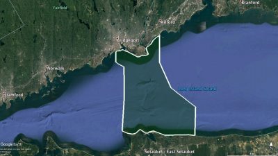
The Long Island Sound Habitat Mapping Initiative began in the one of the highest priority area in the central Sound that was designated the Phase I Pilot Area. The objective was to utilize this area to evaluate the entire process needed to comprehensively map the seafloor habitats and develope the desired products on a subset of the larger LIS project area. Phase I activities included all data collection, analysis, data organization, and product development tasks that were anticipated to be needed within the larger LIS project area. The Pilot Project area is approximately 462 km2 in size, encompassing Connecticut and New York water between Bridgeport, CT and Setauket, NY.
The finalized list of recommended products to be collected and generated by the Steering Committee include:
• Acoustic Intensity – Acoustic intensity products are able to depict valuable properties about the composition, roughness, and texture of the seafloor to provide meaningful information to managers about the distribution and composition of seafloor habitats.
• Seafloor Topography – Seafloor topography products showing bathymetry and terrain relief are able to depict important features and seafloor changes to better explain physical, geological, and ecological processes.
• Benthic Habitat and Ecological Processes – Maps depicting seafloor habitats and their ecological communities are critical for many environmental management, conservation, and research activities, and for the growing focus on coastal and marine spatial planning. Such maps depict either separately or in combination the spatial distribution and extent of benthic habitats classified based on physical, geological, geomorphological, and biological attributes and the benthic communities that reside in the mapped habitats. Additionally, maps can be produced that depict ecological process across the sea floor.
• Sediment Texture and Grain Size Distribution – Mud, sand, and gravel dominated areas provide very different habitats and the main grain size often determines many seafloor characteristics. Therefore grain size composition and sediment texture of the seafloor are essential elements of any habitat classification and detailed knowledge of the seafloor are essential elements of any habitat classification and detailed knowledge of grain size distribution is the basis for many management decisions.
• Sedimentary Environments (Physical) – Besides grain size the stability and suitability for different habitats for various species depend on the dominating sedimentary environment characterized by processes such as erosion, deposition, and transportation. Mapping and understanding these processes in detail is important for understanding habitats as well as their potential to change.
• Physical and Chemical Environments Products that depict the distributions and variability of environmental characteristics like temperature, salinity, dissolved oxygen and bottom stress are central elements of habitat classification. They are also important for wise regulation and planning for dredging and other engineering activities in the coastal ocean.
In addition to these data products, the Pilot Project Scope of Work also identified project Coordination, Management, and Reporting constructs to guide partner interaction and implementation as well as a Data Management component to address the proper storage, organization and data access requirements. The results of the Pilot Project were compiled in a Final Report with Appendixes that are available online at: http://longislandsoundstudy.net/research-monitoring/seafloor-mapping.