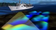
To understand a world that is alien to us – such as the underwater world – requires that we rely upon technologies to address the many inherent challenges of studying beneath the ocean. From temperature, to light, to pressure, to salinity; the features of the ocean combine to create a hostile environment for both humans and the tools used to study beneath the sea. Further, the comprehensive information needed to manage Long Island Sound and its resources must be gathered at a range of scales – from the big picture view of the features of the underwater landscape to the fine scale distribution of organisms living on and in the seafloor. Therefore the technologies being utilized by the Long Island Sound Habitat Mapping Initiative’s teams of scientists rely upon a diversity of approaches – acoustic systems, physical sampling tools and imaging technologies. The results of the data generated by this suite of tools is ultimately combined to provide a three-dimensional perspective of the Sound’s underwater ecosystem.

 with labels indicating the technologies on board")
 with labels indicating the technologies on board")
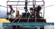
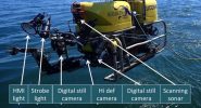
Click on the images to learn more about these mapping technologies.