Looking out the window on a cross-country flight we are presented with an immense diversity of landscapes, many altered by man – from vast city skylines to endless patchworks of fields and farms. We also see vast tracks of forests, prairies and mountain ranges often mantled with snow. When we opt to travel by car or by foot we are able to observe up close the great diversity of our world, from the homes, the shops and factories to the rivers, streams and forest glades. We gain an appreciation and understanding of our world through these observations, especially when combining the 30,000-foot view with those we make of the butterflies in our backyard flowerbeds
Modern maps are the unifying tool that allows us to understand the spatial relationships of these things we observe in our world and provide new insights into their organization. As such, maps become a key decision aid for us to wisely manage our actions and guide our choices of how to best co-exist with one another and mother nature. Detailed maps of our homes and neighborhoods are readily available at our town hall and state offices to provide the information necessary to manage our communities.
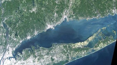
But when we fly over Long Island Sound we only see a blanket of blue, bordered by extensive human development, sandy beaches, marshlands or rocky outcrops with an occasional white wake drawn by a boat of commerce or pleasure. What lies below this blue horizon remains unseen and therefore largely unknown to most of society. The seafloor habitats of the Sound are as diverse as those on land and similarly harbor a diversity of life that is essential to our well-being.
The annual value of the resources and services provided by Long Island Sound has been estimated at $5.5 billion in an earlier study (Atlobello, 1992) to $17-37 billion in a more recent, comprehensive study (Kocian et al, 2015). Kocian et al. applied multiple approaches to measure the value of the sound and included a wide range of ecosystem goods and services. The many valuable goods and services derived from the Sound include food, recreational and commercial fishing, tourism, marine transportation, wildlife habitat, flood and storm mitigation and water filtration.
The many resources of the Sound attract many uses and users, many of which can conflict with one another. As on land, when this happens choices must be made, and up to date, detailed maps of the natural resources ensure that decisions made are science-based and account for all of the possible alternatives.
References
A. Altobello, “The Economic Importance of Long Island Sound’s Water Quality Dependent Activities,” U.S. EPA Report. Storrs, CT, 1992
Kocian, M., Fletcher, A., Schundler, G., Batker, D., Schwartz, A., Briceno, T. 2015. The Trillion Dollar Asset: The Economic Value of the Long Island Sound Basin. Earth Economics, Tacoma, WA.