Mapping the seafloor with acoustic technologies provides the large scale view of the seafloor landscapes – similar to the perspectives provided by satellite imagery of the earth. Modern sonar systems provide detailed water depth information (bathymetry) that is used to construct detailed three dimensional topographic maps of the seafloor. Moreover they also record “backscatter” data, which measures the strength of the reflection of the sound bouncing from the seafloor that provides a good indication of the bottom type, with soft muds absorbing much of the sound and conversely hard bottoms reflecting a lot of the sound back to the sonar.
The Phase I Acoustic Mapping effort combined the data generated by NOAA’s Office of Coast Survey, the Stony Brook University and the University of Rhode Island. An overview of these activities was provided in the Long Island Sound Studies Sound Update available here: Acoustic Mapping.pdf.pdf
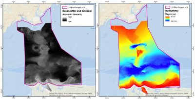
The following summarizes the results of the Phase I Pilot Project:
- Understanding the geophysical composition and relief of the seafloor is a fundamental precursor for explaining the ecological, physical, sedimentary, and oceanographic components of Long Island Sound.
- While a number of technical approaches can be used to measure the topography and composition of surficial seafloor habitats, given the range of water depth and water clarity within the Pilot Project area, acoustic systems (i.e. ship-mounted multibeam and sidescan systems) were implemented to overcome those challenges.
- Seafloor topography products showing bathymetry and terrain relief are able to depict important features, relief, and seafloor changes. Additionally, acoustic sonars are able to measure the intensity of sound reflected off the seafloor to better understand the composition and types of benthic habitats.
- The acoustic products processed for the Pilot Project provided the fundamental spatially organizing information for the analysis conducted in subsequent chapters of the report. The geophysical information contained in the acoustic products conveys important details describing the shape, composition, extent, and composition of surficial features and were used to extract detailed information about benthic habitats, sediment texture, grain size, and sedimentary environments. The acoustic products are used to infer and extract seascape features at a range of spatial scales including fine scale biotopes (Auster et al. 2009) and broader scale geomorphology within Long Island Sound.
- The acoustic products produced a clear demonstration of the value of collaboration. Acquiring data for the size of the Pilot Project area can be a costly endeavor, but close coordination between groups ensured the maximization of the collection area while minimizing data collection duplication so as to produce a valuable product.
- Part of the tasks associated with acoustic data collection included the compilation and evaluation of existing data. While most of the existing data was not used in the final integrated product, it was valuable for planning where field sampling should occur, and identifying locations that would benefit from more contemporary data collections.
These summary findings were extracted from and can be accessed by clicking on the Phase I Final Report and Appendixes.
These are also accessible from the Long Island Sound Study page found here: http://longislandsoundstudy.net/research-monitoring/seafloor-mapping