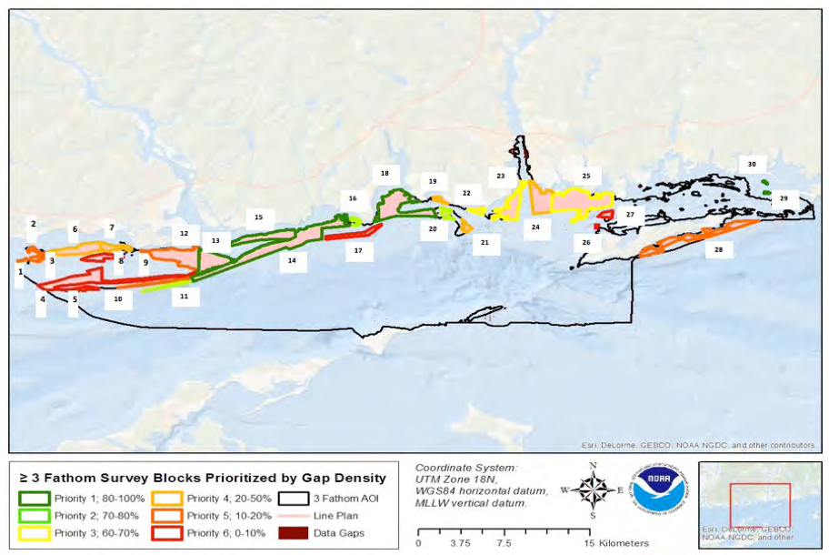
Blocks identified for acoustic mapping in the Phase II area
Shallow Water Acoustic Mapping
The first step in benthic habitat mapping has typically been the collection and analysis of high-resolution acoustic bathymetric and backscatter data that reveal seabed features, sedimentary processes, and sediment distribution patterns. The LIS Cable Fund teams identified 30 areas in the Phase II area requiring additional acoustic mapping, particularly in shallow water.
Click here to access the spatial data and associated metadata.
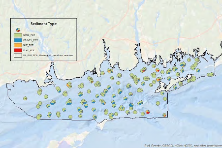
Map of sediment type distribution in the Phase II area
Sediment Texture and Grain Size Distribution
Sediment characterization is a critical component of habitat mapping and includes the shape, size, and spatial arrangement of sediment particles. Sediment grain size directly influences the species that can inhabit a particular area, so gravel, sand, silt and clay and various mixtures of these major grain size classes are relevant attributes for classifying benthic habitats.
Click here to access the spatial data and associated metadata.
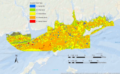
Map of acoustic patch types classified in the Phase II area
Seafloor/Habitat Characterization
Several types of data representing different seafloor characteristics were used to classify and subsequently characterize the seafloor in the study area. These included a multibeam backscatter mosaic, bathymetry, seafloor rugosity as measured by the Terrain Roughness Index (TRI), maximum physical bottom stress, and sediment grain-size composition. A series of analyses were conducted using these data to develop acoustic patch types that represent general habitat areas with distinct environmental characteristics that are potential determinants of the kinds of infaunal and epifaunal communities that may be found within them.
Click here to access the spatial data and associated metadata.
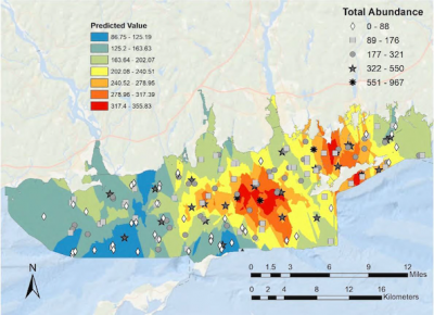
Total abundance of infauna in the LIS Phase II study Area
Ecological Characterization
Ecological characterization is, arguably, one of the most important aspects of benthic habitat mapping, as it provides the detailed information about the living resources living in an area that potentially are impacted by human activities. The infauna, or those organisms that live in the seafloor sediments, are important components of the Sound's ecosystem, either as food sources for other commercially and ecologically important species, or as bio-engineers structuring the seafloor. Similarly, the epifauna, those organisms that live on the seafloor, are also important food sources and provide physical structure that other species use as habitat.
Click here to access the spatial data and associated metadata.
Map of bottom stress due to tides in the Phase II area
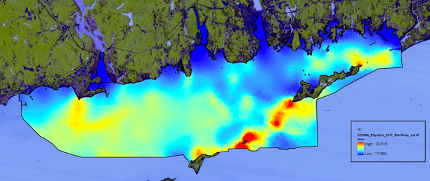
Physical Oceanographic Characterization
The physical oceanographic environment impacts all of the other attributes of the seafloor habitat mapping initiative. The LISMaRC team employed multiple observations of the physical oceanography of the Phase II area using shipboard sampling systems and seafloor observatories. These data were integrated into the LIS FVCOM model to produce predictive maps of bottom temperature, salinity, bottom stress and tidal and subtidal currents, all of these parameters greatly influence the distribution of benthic fauna.
Click here to access the spatial data and associated metadata.