To most effectively use the Cross Sound Cable Fund, regional stakeholders were surveyed to help identify areas that most needed to be mapped; their input addressed several factors including ecological value, multiple uses, and development pressure. In addition, representatives from state, federal, academic institutions and other collaborators participated in a Spatial Prioritization Workshop (8/3-4/2011) to further identify critical management applications of the information to be produced, spatial prioritization within Long Island Sound, and key data sources and derived products needed. This input was used to help guide the selection of a Phase I Pilot Area in central Long Island Sound that would serve as an operational test-bed for a multi-year habitat mapping effort. This would be followed by Phases 2 and 3 that would include completion of remaining priority areas identified in Long Island Sound. A detailed description of the process used to prioritize the areas to be mapped can be found here:
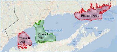
Map of Long Island Sound indicating the areas identified through workshops and surveys as high priority for habitat mapping.