A five-day cruise using the research vessel Connecticut (RV CT) and the Kraken2 (K2) ROV was conducted from May 19-23rd, shortly after the RV CT/SEABOSS cruise. The mission visited 12 of the sample blocks and sites that were identified as being inadequately sampled by the SEABOSS system. This determination was based primarily upon the nature of the substrate being too hard and topographically complex to sample with the SEABOSS. The drift-mode sampling approach of the SEABOSS did not allow extended imaging of the rougher boulder/ledge habitats. The K2 ROV, conversely, is ideally suited to stopping and imaging the vertical surfaces of boulder habitats with great detail with its powerful zoom cameras (both hi-definition video and high resolution digital still). In addition a survey of a previously unidentified wreck site discovered by the SEABOSS was attempted. However, low visibility and high currents precluded adequate documentation of this site. The K2 collected over 30 hours of hi-definition digital video (~2 terabytes) and 412 down-looking and 2050 forward-looking digital still images that will be analyzed over the next year to assess the sites’ community structure and biodiversity.
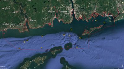
Map depicting the locations of the Kraken2 ROV Spring 2018 dive sites. The red boundary illustrates the extent of the Phase II area.
The K2 ROV cruise revealed some of the most complex terrain observed in the Sound to date. To see an example video, click on this link: https://youtu.be/XKVNCYrSJwo