The Long Island Sound Cable Fund
In June 2004, a court settlement brought by the states of Connecticut and New York against the Cross Sound Cable Company resulted in a fund that was to support projects to enhance Long Island Sound (LIS) and to improve understanding of the biological, chemical and physical effects of existing or potential cables and pipelines crossing the Sound. The Long Island Sound Study Policy Committee signed a Memorandum of Understanding on administering the fund for research and restoration projects to enhance the waters and related natural resources of Long Island Sound. In 2006, the Long Island Sound Study Policy Committee signed a second Memorandum of Understanding formally establishing a framework for the fund’s use. The Policy Committee agreed that the Fund be used to: “Emphasize benthic mapping as a priority need, essential to an improved scientific basis for management and mitigation decisions.” Therefore, the settlement fund, currently valued at more than $7 million, is being directed toward seafloor mapping activities over the next several years.
This improved spatial information of the benthic environment of LIS will both identify areas of special resource concern, as well as identify areas that may be more suitable for the placement of energy and other infrastructure. The comprehensive mapping activities will assist managers in the States of Connecticut and New York, Connecticut and New York Sea Grant programs, and the U.S. Environmental Protection Agency (USEPA) with their mandates to preserve and protect coastal and estuarine environments and water quality of Long Island Sound. The ultimate goal is to balance competing human uses and energy needs with protection and restoration of essential ecological function and habitats.
The Long Island Sound Seafloor Mapping Workshop
The Connecticut Department of Energy and Environmental Protection (DEEP) Office of Long Island Sound Programs (OLISP), the University of Connecticut Marine Sciences Department, and the EPA Long Island Sound Study hosted a Long Island Sound Seafloor Mapping Workshop in November, 2007 at Fort Trumbull, CT. The goal of the workshop was to identify and understand the research and management issues that would benefit from new investments in seafloor mapping in the Sound, and was envisioned as the first step of developing a Strategic Seafloor Mapping Plan. Prior to the workshop the invitees were queried via a survey to identify the priority research and management needs, from which four major themes were identified in the following priority:
Species and Habitats – included reference to the seafloor areas or environments where organisms or ecological communities normally live or occur. This category also included identification of mapping needs for important species or biological communities;
Infrastructure Projects – included reference to/about structures placed in the Sound such as cables, pipelines, dredged sediment disposal sites, and structures placed to support aquaculture, docks, piers, and bulkheads;
General Mapping and Ocean Management – captured recommendations for mapping all of the Sound for a specific purpose. Ocean management was used to capture concepts such as marine zoning, marine protected areas and reference (long-term monitoring) sites:
Coastal Hazards and Geology – included topics such as inundation from storm surge, shoreline erosion, and sedimentation. Also included here are search and rescue and dredged material management.
The most important features to be mapped included sediment type, bathymetry and habitat mapping.
Development of the Request for Qualifications and Interest
In April 2010, the State of Connecticut Department of Energy and Environmental Protection Office of Long Island Sound Programs released a Request for Qualifications and Interest (RQI). The RQI explicitly stated that this project will “address the need for acquiring, managing, interpreting, and making publically available datasets on the spatial distribution of benthic resources in Long Island Sound. The goal of the cooperative is to comprehensively map the bathymetry and surficial geology of the seafloor in Long Island Sound to help increase the understanding of seafloor habitat and improve resource management.”
Subsequent to the announcement of the RQI, three entities were selected by the steering committee as interested and qualified to perform the activities needed. They include: 1) Lamont –Doherty Earth Observatory (LDEO) Collaborative, 2) Long Island Sound Mapping and Research Collaborative (LISMaRC), and 3) NOAA’s Ocean Service Collaborative.
The Long Island Sound Mapping Initiative
To most effectively use the Cross Sound Cable Fund, regional stakeholders were surveyed to help identify areas that most needed to be mapped; their input addressed several factors including ecological value, multiple uses, and development pressure. This input was used to help guide the selection of a pilot area in the central Long Island Sound that would serve as an operational test-bed for a multi-year habitat mapping effort.
The collective State, Federal, and collaborative entities participated in a Spatial Prioritization Workshop (8/3-8/4/11) to further identify critical management applications of the information to be produced, spatial prioritization within Long Island Sound, and key data sources and derived products needed. One outcome of the Workshop was the identification of a staged project completion strategy in which Phase 1 would include a completion of a Pilot Project and Phase 2 would include completion of remaining priority areas in Long Island Sound.
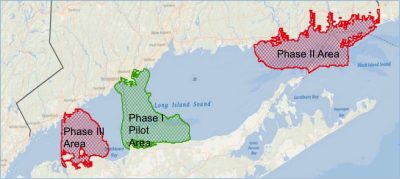
Map of Long Island Sound indicating the areas identified through workshops and surveys as high priority for habitat mapping.
Phase 1 Pilot Project
The Pilot Project was intended to evaluate the entire process needed to complete the desired products on a subset of the larger LIS project area. It included all data collection, analysis, data organization, and product development tasks that are anticipated to occur within the larger LIS project area. The Pilot Project area is approximately 462 km2 in size, encompassing Connecticut and New York water between Bridgeport, CT and Setauket, NY.
The finalized list of products recommended to the Steering Committee include:
- Acoustic Intensity – Acoustic intensity products are able to depict valuable properties about the composition, roughness, and texture of the seafloor to provide meaningful information to managers about the distribution and composition of seafloor habitats.
- Seafloor Topography – Seafloor topography products showing bathymetry and terrain relief are able to depict important features and seafloor changes to better explain physical, geological, and ecological processes.
- Benthic Habitat and Ecological Processes – Maps depicting seafloor habitats and their ecological communities are critical for many environmental management, conservation, and research activities, and for the growing focus on coastal and marine spatial planning. Such maps depict either separately or in combination the spatial distribution and extent of benthic habitats classified based on physical, geological, geomorphological, and biological attributes and the benthic communities that reside in the mapped habitats. Additionally, maps can be produced that depict ecological process across the sea floor.
- Sediment Texture and Grain Size Distribution – Mud, sand, and gravel dominated areas provide very different habitats and the main grain size often determines many seafloor characteristics. Therefore grain size composition and sediment texture of the seafloor are essential elements of any habitat classification and detailed knowledge of the seafloor are essential elements of any habitat classification and detailed knowledge of grain size distribution is the basis for many management decisions.
- Sedimentary Environments (Physical) – Besides grain size the stability and suitability for different habitats for various species depend on the dominating sedimentary environment characterized by processes such as erosion, deposition, and transportation. Mapping and understanding these processes in detail is important for understanding habitats as well as their potential to change.
- Physical and Chemical Environments Products that depict the distributions and variability of environmental characteristics like temperature, salinity, dissolved oxygen and bottom stress are central elements of habitat classification. They are also important for wise regulation and planning for dredging and other engineering activities in the coastal ocean.
In addition to these data products, the Pilot Project Scope of Work also identified project Coordination, Management, and Reporting constructs to guide partner interaction and implementation as well as a Data Management component to address the proper storage, organization and data access requirements. The results of the Pilot Project were compiled in a Final Report with Appendixes that are available online at: http://longislandsoundstudy.net/research-monitoring/seafloor-mapping.