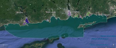
The Phase II of the Long Island Sound (LIS) Cable Fund Habitat Mapping initiative is now mostly complete, with only the results of a few sediment samples yet to be reported. This multi-year, interdisciplinary effort is supported by the LIS Cable Fund and administered by the Connecticut Department of Energy and Environmental Protection (CT-DEEP). Phase II began in March, 2017 and is focused on eastern LIS, from west of the Connecticut River to Fishers Island Sound.

The mapping effort combines acoustically derived maps of the water depth (bathymetry and topography), seafloor hardness (as measured by acoustic reflection strength or backscatter) and sediment profiles that provide a historical picture of the area. Direct physical sampling of the sediments using grabs provide information on the grain size allow for infaunal (what lives in sediment) characterization. Video and still imaging of the seafloor provides epifaunal (what lives on the seafloor) characterization. Long-term measurement of the bottom water current strength further characterizes the seafloor habitat. All of these data are combined in Geographic Information System (GIS) maps to provide comprehensive, up-to-date information to better manage the Sound, especially in light of the many current and proposed uses of the Sound.
The data from the Phase II study is now available here.
As in the Phase I Pilot project the Phase II effort is being conducted by three teams of experts from academia, state and federal agencies. The Long Island Sound Mapping and Research Collaborative (LISMaRC) is comprised of scientists, technicians and students from the University of Connecticut, the University of New Haven and the U.S. Geological Survey. The Lamont Doherty Earth Observatory (LDEO) at Columbia University is leading the second team that also includes researchers from Stony Brook University and Queens College. The third team represents the National Oceanic and Atmospheric Administration’s (NOAA) National Centers for Coastal Ocean Science (NCCOS).